- W
-
Waste Water Management Solution
GEOINFO provides modular, digital solutions for sustainable, forward‑looking, and efficient infrastructure management. The focus lies on managing technical and ecological infrastructures throughout their entire life cycle – from condition assessment to controlling.
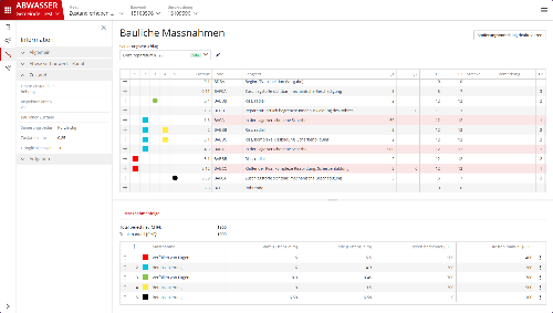
The wastewater management solution ensures compliance with legal regulations and is designed for public authorities, private infrastructure managers, engineering and planning offices, companies, spatial planners, site developers, and property managers. The solution can be licensed in modular form and offers the following functionalities:
Condition Assessment: AI‑supported damage analysis, urgency evaluation, and data historization.
Measures & Maintenance: Planning, cost forecasting, optimized cleaning, and digital work order management.
Controlling: Automated key figures, reports, and clear task lists.
- Price
- On request
- Technology
- GEOINFO develops modern web and geo‑specialized applications based on Angular, TypeScript, NodeJS, and .NET technologies, and relies on established OSGeo components such as GeoServer as well as relational and geospatial database systems like PostgreSQL/PostGIS. Our solutions follow recognized OGC standards and make use of proven open‑source tools.
- Hosting
- in Switzerland
- Company
- GEOINFO Applications AG More about the provider
- R
-
Road Infrastructure Solution
GEOINFO provides modular, digital solutions for sustainable, forward‑looking, and efficient infrastructure management. The focus lies on managing technical and ecological infrastructures throughout their entire life cycle – from condition assessment to controlling.
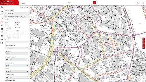
The road infrastructure solution ensures compliance with legal regulations and is designed for public authorities, private infrastructure managers, engineering and planning offices, companies, spatial planners, site developers, and property managers. The solution can be licensed in modular form and offers the following functionalities:
Condition Assessment: AI‑supported damage analysis, urgency evaluation, and data historization.
Measures & Maintenance: Planning, cost forecasting, and digital work order management.
Controlling: Automated key figures, reports, and clear task lists.
- Price
- On request
- Technology
- GEOINFO develops modern web and geo‑specialized applications based on Angular, TypeScript, NodeJS, and .NET technologies, and relies on established OSGeo components such as GeoServer as well as relational and geospatial database systems like PostgreSQL/PostGIS. Our solutions follow recognized OGC standards and make use of proven open‑source tools.
- Hosting
- in Switzerland
- Company
- GEOINFO Applications AG More about the provider
- G
-
Geospatial Information Systems
Custom GIS development at Novel-t addresses industry-specific requirements by enhancing data visualization, analysis, and operational efficiency. Using technologies such as Esri, PostgreSQL, GeoServer, OpenLayers, and PostGIS, we develop scalable geospatial solutions that integrate with existing systems and workflows. Sectors like healthcare, urban planning, and logistics benefit from tools that automate processes, provide real-time insights, and support accurate, informed decision-making.
- Price
- On request
- Technology
- ESRI, QGIS, PostGIS, PostgreSQL, GDAL, OpenLayers, GeoServer
- Hosting
- in Switzerland
- Company
- Novel-T More about the provider
-
Geoportal
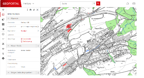
GEOINFO’s geoportal supports public administrations and the private sector in their daily work and provides important information to private individuals. At www.geoportal.ch, all spatial data from more than 400 municipalities across eleven cantons is consolidated — including in three dimensions.
At Geoportal.ch, the needs of the users take center stage. All functions and tools are context‑sensitive and intelligently aligned with existing workflows. The portal runs on all devices and automatically adapts to any environment. A powerful full‑text search, map overlays, synchronized map comparisons, and time-based comparisons of historical geodata are part of the core functionalities. These are complemented by high‑performance tools for users’ own data collection, processing, and analysis.
- Price
- On request
- Technology
- GEOINFO develops modern web and geo‑specialized applications based on Angular, TypeScript, NodeJS, and .NET technologies, relying on established OSGeo components such as GeoServer as well as relational and geospatial database systems like PostgreSQL/PostGIS. Our solutions follow recognized OGC standards and make use of proven open‑source tools.
- Hosting
- in Switzerland
- Company
- GEOINFO Applications AG More about the provider
-
GIS development & Hosting
Our activity revolves around developing Geographic Information Systems (GIS) and providing comprehensive hosting solutions. We specialize in various aspects of GIS development, including field data acquisition through advanced technologies like lasers, drones, and mobile mapping. We excel in collecting, transforming, and correcting geodata, ensuring accuracy and reliability. Our expertise extends to geocoding, geolocation, and the creation of custom geocoders, enabling precise spatial analysis.
We are adept at modeling geodatabases in diverse formats such as 2D, 3D, real-time, historical, and big data, tailoring solutions to meet specific project requirements. Our consultancy services encompass GIS architecture design, offering expert guidance on system integration and optimization. We assist clients in seamlessly integrating proprietary and open-source GIS platform applications, maximizing functionality and interoperability.
Moreover, we provide comprehensive training and ongoing support to empower organizations in leveraging GIS technologies effectively.
- Price
- On request
- Hosting
- in Switzerland
- Company
- GeoDataSolutions More about the provider