- G
-
Geoportal
GEOINFO is known as a software development company for individual desktop- and websolutions with databases. Development of Geographical Information systems is part of our core competences.
- Price
- On request
- Technology
- GEOINFO develops with Microsoft .NET-technologies and databases like Oracle and MS SQL-Server. Wi also use open source components.
- Hosting
- in Switzerland
- Company
- GEOINFO Applications AG More about the provider
-
GIS development & Hosting
Our activity revolves around developing Geographic Information Systems (GIS) and providing comprehensive hosting solutions. We specialize in various aspects of GIS development, including field data acquisition through advanced technologies like lasers, drones, and mobile mapping. We excel in collecting, transforming, and correcting geodata, ensuring accuracy and reliability. Our expertise extends to geocoding, geolocation, and the creation of custom geocoders, enabling precise spatial analysis. We are adept at modeling geodatabases in diverse formats such as 2D, 3D, real-time, historical, and big data, tailoring solutions to meet specific project requirements. Our consultancy services encompass GIS architecture design, offering expert guidance on system integration and optimization. We assist clients in seamlessly integrating proprietary and open-source GIS platform applications, maximizing functionality and interoperability. Moreover, we provide comprehensive training and ongoing support to empower organizations in leveraging GIS technologies effectively.
- Price
- On request
- Hosting
- in Switzerland
- Company
- GeoDataSolutions More about the provider
- M
-
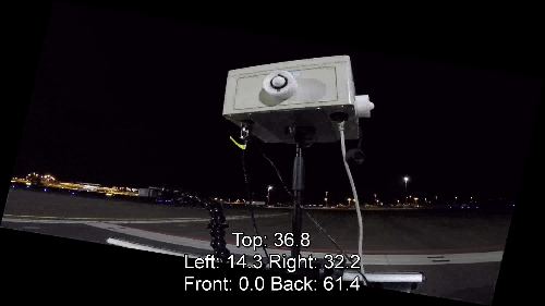
MovingSensors
MovingSensors was developed for measuring the illuminance of very large areas (for example airports). The methodology and hardware MovingSensors allows to measure the illuminance with very high temporal and spatial resolution. With an average movement speed of about 2m/s, large areas can be covered and measured in a short time. Due to the fast measurement speed, the time in which, for example, areas on an airfield have to be closed is drastically reduced. After the measurement runs, the data is evaluated in a spatial context and made available to the customer.
- Price
- On request
- Hosting
- in Switzerland
- Company
- GeoIdee Weidmann More about the provider
- R
-
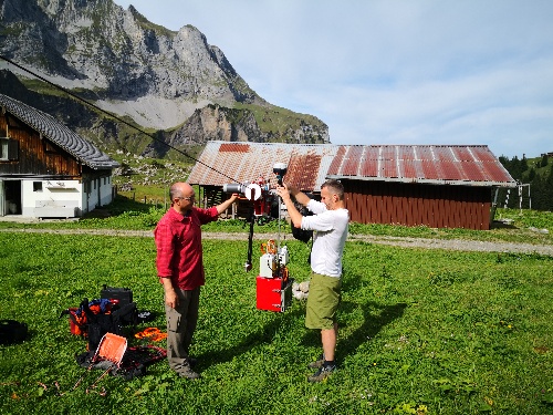
RopeTracker
The RopeTracker is a device that can be mounted on very thin suspension ropes and ropeways. The RopeTracker is operated by one person with a remote control. During the ride, the RopeTracker registers the entire course of the rope in all three spatial dimensions. The data thus recorded is used for the detection of aerial obstacles. This data is relevant information for helicopter pilots, especially in mountainous regions.
- Price
- On request
- Hosting
- in Switzerland
- Company
- GeoIdee Weidmann More about the provider
- T
-
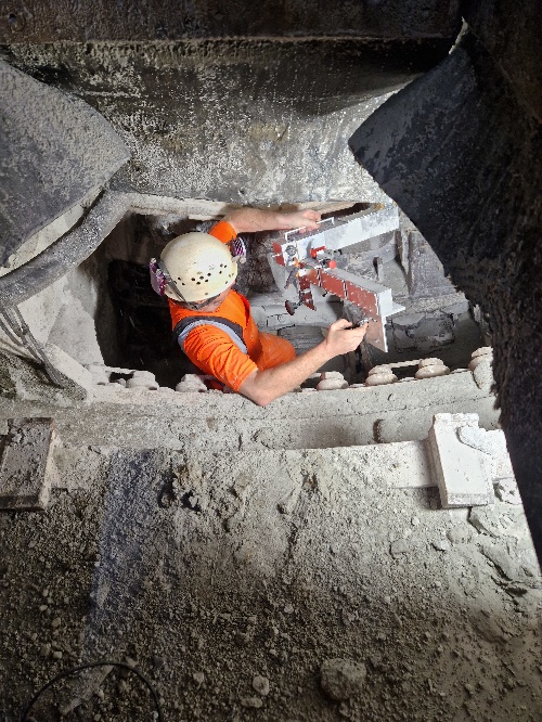
TBMFaceCapture
The TBMFaceCapture product was developed exclusively for Implenia-Tunneling. The device, mounted in the boring head of a tunnel boring machine, captures the face milled out by the tunnel boring machine with a large number of photographs. The individual photographs are converted into an absolutely geo-referenced 3D model after they have been taken. The calculated 3D model is then used by the geologists to reconstruct the structure of the face and the geology.
- Price
- On request
- Hosting
- in Switzerland
- Company
- GeoIdee Weidmann More about the provider